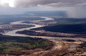
Limpopo River
| Limpopo | |
|---|---|
 Limpopo River in Mozambique |
|
| Mouth | Indian Ocean |
| Basin countries | South Africa, Botswana, Zimbabwe, Mozambique |
| Length | 1,750 km (1,087 mi) |
| Avg. discharge | 170 m3/s (6,200 cu ft/s) at mouth |
| Basin area | 415,000 km2 (160,200 sq mi) |
The Limpopo River rises in central southern Africa, and flows generally eastwards to the Indian Ocean. It is around 1,750 kilometres (1,087 mi) long, with a drainage basin 415,000 square kilometres (160,200 sq mi) in size. Its mean annual discharge is 170 m³/s (6,200 cu ft/s) at its mouth.[1] The Limpopo is the second largest river in Africa that drains to the Indian Ocean, after the Zambezi River.
Contents |
Course

The Limpopo river flows in a great arc, first zigzagging north and then northeast, then turning east and finally southeast. Then it serves as a border for about 640 kilometres (398 mi), separating South Africa to the southeast from Botswana to the northwest and Zimbabwe to the north. There are several rapids as the river falls off Southern Africa's inland escarpment. In fact where the Marico River and the Crocodile River join the name changes to Limpopo River.
Its main tributary is the Olifants River (Elephant River), contributing around 1,233 Mm3 per year)[2]. Other major tributaries include the Shashe River, Mzingwane River, Crocodile River, Mwenezi River and Luvuhu River.
The port town of Xai-xai, Mozambique is on the river near the mouth. Below the Olifants, the river is permanently navigable to the sea, though a sandbar prevents access by large ships, except at high tide.
At the north-eastern corner of South Africa the river borders Kruger National Park. Tributaries such as the Oliphants River flow through the park.
Basin characteristics
The waters of the Limpopo are sluggish and silty. Rainfall is seasonal and unreliable. In dry years, the upper parts of the river flow for 40 days or less. The upper part of the drainage basin is arid, in the Kalahari Desert, but becomes less arid further down the river. The next reaches drain the Waterberg massif, a biome of semi-deciduous forest and low density human population.[3] The lower reaches are fertile and heavily populated. Floods after the rainy season are an occasional problem in the lower reaches, most notably the catastrophic floods in February 2000, which were caused by heavy rainfall due to a cyclone.
The Limpopo basin is home to about 14 million people.
History
Vasco da Gama was probably the first European to sight the river, when his first expedition anchored off the mouth in 1498. However, there has been human habitation in the region since time immemorial — sites in the Makapans Valley near Mokopane contain Australopithecus fossils from 3.5 million years ago.

The Limpopo was immortalized in the short story "The Elephant's Child" by British author Rudyard Kipling, in the Just So Stories, where it is described as "the great grey-green, greasy Limpopo River, all set about with fever-trees," where the "Bi-Coloured Python Rock-Snake" dwells.[4]
Resources
Two studies of the Limpopo River conducted by the Environment and Production Technology Division at the International Food Policy Research Institute: Climate change implications for water resources in the Limpopo River Basin and Green and blue water accounting in the Limpopo and Nile Basins.
References
- ↑ Nakayama, Mikiyasu (2003). International Waters in Southern Africa. United Nations University Press. pp. 9. ISBN 9280810774.; online at Google Books
- ↑ Görgens, A.H.M. and Boroto, R.A. 1997. Limpopo River: flow balance anomalies, surprises and implications for integrated water resources management. In: Proceedings of the 8th South African National Hydrology Symposium, Pretoria, South Africa.
- ↑ C.Michael Hogan, Mark L. Cooke and Helen Murray, The Waterberg Biosphere, Lumina Technologies, May 22, 2006. [1]
- ↑ The Elephant's Child, Rudyard Kipling
|
|||||
|
|||||